Field operations optimization
Empower field staff and citizen scientists to view and collect mission-critical data directly from their mobile devices.
Every day, the scientific community uses GIS to address twenty-first-century environmental challenges and understand the changing world. A strong scientific enterprise will yield new tools for analysis and investigation to increase our capacity to question, learn, and advance.
SUCCESS STORY
Learn the innovative public-private partnership led by Esri and the United States Geological Survey (USGS) to create the Ecological Marine Units (EMUs), a 3D representation of the world's oceans.
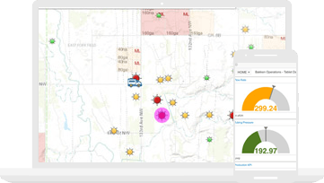
Connect your field data collection staff with the office. Give your entire team access to the same authoritative data to reduce errors, boost productivity, and save money.
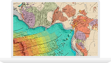
Use intuitive 2D and 3D mapping to create visualizations, perform complex scientific analysis, conduct image processing, and improve data management and integration.

Combine authoritative maps with narrative text, images, and multimedia content. Easily harness the power of maps and geography to tell your story.

Esri User Conference (UC)
July 8-12, 2019 | San Diego, California

American Geophysical Union (AGU)
December 9-13, 2019 | San Francisco, Calf.

American Meteorological Society (AMS)
January 12-16, 2020 | Boston Massachusetts

Esri Federal GIS Conference (FedGIS)
February 11-12, 2020 | Washington, D.C.