Pre-enumeration planning
Plan your work, update basemaps, optimize enumeration areas (EAs), and increase efficiencies with GIS.
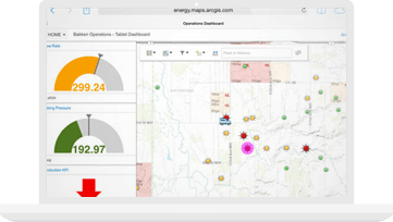
Statistical and civil registration products inform national decision-making. To ensure high-quality data, organizations need a statistical geospatial framework that integrates geospatial and statistical data. GIS platforms facilitate the requisite collection of accurate information as well as its dissemination and analysis.
SUCCESS STORY
Governments are addressing the challenges of their upcoming population censuses and are realizing the need for modernization of their processes and methods. With GIS technology, the US Census was able to gain efficiencies, increase accuracy, and improve collaboration—all while reducing costs.


Learn ArcGIS for Official Statistics
Official Statistics Modernization Program
Providing resource constrained countries with the GIS tools and training needed to conduct a successful 2020 census.
GIS and the 2020 Census
Modernizing Official Statistics

ISI & Esri Student Competition

Esri User Conference
Applied Geography Conference 2020
Esri partners offer specialized solutions built on ArcGIS to solve your real-world challenges.